
Despite the El Nino effect, which did drop above-average rainfall in Northern California in the 2015-16 rain year, the year officially ended on September 30 without an end to the drought.
Statewide, this marks the fifth consecutive year of below-average precipitation that fell more often as rain than snow. Record warm temperatures created an early and sparse runoff that was in large part absorbed by parched soil before ever reaching the state’s reservoirs. The water content of the California Sierra snowpack was also well below normal. These dry, warming conditions leading to the decreased water content of the snow has been called a “snow drought” by water officials.
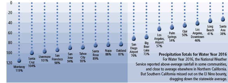
In its recently-released report “Water Year 2016,” the California Department of Water Resources (DWR) leaves no doubt that the drought persists. Water Year 2016 is officially listed in the record books as ‘Dry’ statewide, even though parts of Northern California experienced average to slightly above average precipitation.
The forecast for Water Year 2017 is uncertain. The National Oceanic and Atmospheric Administration’s Climate Prediction Center currently sees slightly better than even odds that weak La Niña conditions will develop this fall and winter. La Niña refers to the periodic cooling of sea-surface temperatures across the east-central equatorial Pacific. It represents the cold phase of the El Niño/Southern Oscillation cycle, nature’s year-to-year variations in oceanic and atmospheric conditions. La Niña is the opposite phase of the warm, El Niño effect that California experienced this past water year. There are no guarantees for substantial La Niña rainfall. Water officials warn that making seasonal forecasts of precipitation—the ability to predict now if 2017 will be wet or dry (and how wet or dry)—is scientifically difficult, and the accuracy of such predictions is very low. Historical records are the only source of facts to study for any indication of what California may see in the form of precipitation in coming months. Of the 18 La Niña winters since 1950-51, 16 have provided below average precipitation for Southern California’s coastal region, and 15 winters have resulted in below average precipitation for Southern California’s interior region. Above average precipitation was recorded in 11 winters for the Northern Sierra and in eight years for the Central and Southern Sierra. Water year 2011 brought the only significantly wet La Niña event in this time period.
The report shows that 60 percent of the state currently remains in severe or extreme drought.
DWR Public Information Officer Doug Carlson went through the report with WG&S pointing out many of the deficiencies as he looked at reservoir contents and precipitation numbers for the year. “The snapshot (of where we are now) is not looking good,” he said on Oct. 4.
He noted that last year, with the expected El Nino on the horizon, the state’s official climatologist was widely quoted noting that California needed 150 percent of normal precipitation to pull out of the drought. That did not happen and there is no discussion this year of a one-year fix. “It’s going to take several years of wet conditions to end the drought,” he said.
In fact, even as he spoke, drought conditions continue to increase. He noted that Sacramento received a spate of measurable rain over the first weekend of October, which was the first measurable rain in more than four months. Coming on the first couple of days of October, on October 3, the state was on par with normal precipitation two days into Water Year 2017. By the following day, with no further rain, the state precipitation level was already below par, meaning that early October on average, usually delivers some rain. At this writing a week later, there has been no further rain, though there is a storm in the forecast for mid-October. Seemingly Water Year 2017 is coming in like a lamb rather than a lion.